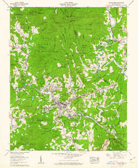
1960 Map of Spruce Pine
USGS Topo · Published 1962About this map
The North Toe River and South Toe River converge near the mountain town of Spruce Pine, which serves as the industrial and transport hub for this portion of the Blue Ridge. The town's development is closely tied to the Clinchfield RR, which threads through the valley and utilizes the Vance Tunnel and Ridge Tunnel to navigate the steep grade toward Altapass. This 1960 survey highlights the region's diverse mineral economy, documented through numerous extraction sites like the Chestnut Flats Mine, Gusher Knob Mine, and an Open pit mine on Wolfden Ridge. Higher elevations are dominated by the Pisgah National Forest, including prominent peaks such as Big Bald and Gusher Knob. Local history is preserved in the location of several country churches and family burial grounds, such as Whites Memorial Ch and the McKinney Cem, alongside civic landmarks like the Harris High Sch.
Find a feature on this map
109 named features on this map. Tap any name to fly to it.
Don’t see what you’re looking for? This feature index may not catch every label — zoom into the map to look around manually.
Map Details
Editions of this 1960 Spruce Pine Map
5 editions found

Other maps of this area

1891 · Roan Mountain
USGS Topo · 1:125,000

1893 · Cranberry
USGS Topo · 1:125,000

1894 · Roan Mountain
USGS Topo · 1:125,000

1895 · Cranberry
USGS Topo · 1:125,000

1899 · Cranberry
USGS Topo · 1:125,000

1900 · Mount Mitchell
USGS Topo · 1:125,000

1902 · Cranberry
USGS Topo · 1:125,000

1902 · Mount Mitchell
USGS Topo · 1:125,000

1904 · Roan Mountain
USGS Topo · 1:125,000

1905 · Morganton
USGS Topo · 1:125,000