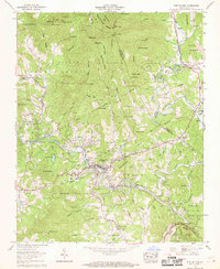
1960 Map of Spruce Pine
USGS Topo · Published 1969About this map
Spruce Pine sits at a critical junction of mountain industry and transport during this 1960 field examination. The North Toe River carves a deep valley through the Pisgah National Forest, followed closely by the Clinchfield railroad line that served the region's mineral wealth. Evidence of this extractive economy is scattered throughout the terrain, from the Chestnut Flats Mine to the Chalk Mine near Chalk Mountain.
Find a feature on this map
82 named features on this map. Tap any name to fly to it.
Don’t see what you’re looking for? This feature index may not catch every label — zoom into the map to look around manually.
Map Details
Editions of this 1960 Spruce Pine Map
5 editions found

Other maps of this area

1891 · Roan Mountain
USGS Topo · 1:125,000

1893 · Cranberry
USGS Topo · 1:125,000

1894 · Roan Mountain
USGS Topo · 1:125,000

1895 · Cranberry
USGS Topo · 1:125,000

1899 · Cranberry
USGS Topo · 1:125,000

1900 · Mount Mitchell
USGS Topo · 1:125,000

1902 · Cranberry
USGS Topo · 1:125,000

1902 · Mount Mitchell
USGS Topo · 1:125,000

1904 · Roan Mountain
USGS Topo · 1:125,000

1905 · Morganton
USGS Topo · 1:125,000