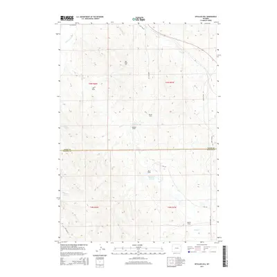
2015 Map of Spyglass Hill
USGS Topo · Published 2015About this map
Spy Glass Hill stands as the central landmark of this ranching landscape where the high plains meet the northern drainage of the Powder River Basin. The terrain is defined by a dense network of intermittent watercourses and draws, including Big Draw, Buck Draw, and Johnson Draw, which drain into the Belle Fourche River and its tributaries like Rush Cr. The human footprint here is primarily agricultural, evidenced by significant water management features such as Betty Reservoir, Thomas Reservoir, and the Watt Brothers Number 2 Reservoir. Long-established ranch roads like Warbonnet Rd and Buffalo Creek Rd weave through the township and range lines of the Crook County and Weston County border, showing the modern infrastructure serving these rural tracts.
Find a feature on this map
25 named features on this map. Tap any name to fly to it.
Don’t see what you’re looking for? This feature index may not catch every label — zoom into the map to look around manually.
Map Details
Editions of this 2015 Spyglass Hill Map
This is the sole edition of this map. No revisions or reprints were ever made.
Other maps of this area
1918 · Moorcroft
USGS Topo · 1:125,000
1918 · Moorcroft
USGS Topo · 1:62,500

1954 · Gillette
USGS Topo · 1:250,000

1955 · Gillette
USGS Topo · 1:250,000
1957 · Moorcroft
USGS Topo · 1:62,500

1958 · Gillette
USGS Topo · 1:250,000

1962 · Gillette
USGS Topo · 1:250,000
1971 · Whitetail Creek SE
USGS Topo · 1:24,000
1971 · Rozet SE
USGS Topo · 1:24,000
1971 · Whitetail Creek NE
USGS Topo · 1:24,000