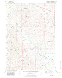
1982 Map of Spyglass Hill
USGS Topo · Published 1982About this map
Spyglass Hill stands as a prominent landmark in this corner of the Powder River Basin, overlooking a landscape defined by industrial development and natural drainage patterns in the early 1980s. The map reveals the extensive reach of energy extraction, dominated by the Coyote Creek Oil Field and the South Coyote Creek Oil Field, where numerous oil wells and drill holes dot the terrain. These petroleum operations are integrated with a transport network including a Burlington Northern railroad line that skirts the northeastern corner along Rush Creek. The hydrology of the area is complex, with the Belle Fourche River winding through the northwest while numerous seasonal watercourses like Buffalo Creek and Coyote Creek carve deep draws across the Crook and Weston county line. Local family-named features such as Bruce Draw and Johnson Draw provide specific points of interest for genealogical research in this Wyoming ranching and oil country.
Find a feature on this map
16 named features on this map. Tap any name to fly to it.
Don’t see what you’re looking for? This feature index may not catch every label — zoom into the map to look around manually.
Map Details
Editions of this 1982 Spyglass Hill Map
This is the sole edition of this map. No revisions or reprints were ever made.
Other maps of this area

1918 · Moorcroft
USGS Topo · 1:125,000

1918 · Moorcroft
USGS Topo · 1:62,500

1954 · Gillette
USGS Topo · 1:250,000

1955 · Gillette
USGS Topo · 1:250,000

1957 · Moorcroft
USGS Topo · 1:62,500

1958 · Gillette
USGS Topo · 1:250,000

1962 · Gillette
USGS Topo · 1:250,000
1971 · Whitetail Creek SE
USGS Topo · 1:24,000
1971 · Rozet SE
USGS Topo · 1:24,000
1971 · Whitetail Creek NE
USGS Topo · 1:24,000