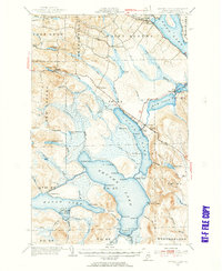
1953 Map of Square Lake
USGS Topo · Published 1955About this map
Saint Agatha and the surrounding unorganized townships of northern Maine appear in this mid-century update, revealing a landscape defined by the interconnected waters of the Fish River Chain of Lakes. The map illustrates a remote but industrious territory where Corriveau Mill stands near the northern shores of Long Lake, and small settlements like Sinclair and Guerette bridge the narrow passages between water bodies. The geography is marked by local family and camp names, such as Austin Camp, Michaud Camp, and Fraser Camp, which suggest the area's enduring reliance on timber and seasonal recreation. Moving south, the terrain becomes increasingly complex around Square Lake and Eagle Lake, with prominent points like Abraham Pt and Matrimony Pt punctuating the shoreline. The inclusion of the Halfway Brook Trail and the St Eutropius Cem provides essential touchpoints for genealogists and local historians tracking the early families of Aroostook County.
Find a feature on this map
68 named features on this map. Tap any name to fly to it.
Don’t see what you’re looking for? This feature index may not catch every label — zoom into the map to look around manually.
Map Details
Editions of this 1953 Square Lake Map
4 editions found

Other maps of this area

1927 · Stockholm
USGS Topo · 1:48,000

1927 · Square Lake
USGS Topo · 1:48,000

1928 · Eagle Lake
USGS Topo · 1:48,000

1928 · Winterville
USGS Topo · 1:48,000

1929 · Portage
USGS Topo · 1:62,500

1929 · Caribou
USGS Topo · 1:48,000

1931 · Square Lake
USGS Topo · 1:62,500

1931 · Eagle Lake
USGS Topo · 1:62,500

1931 · Portage
USGS Topo · 1:62,500

1931 · Stockholm
USGS Topo · 1:62,500