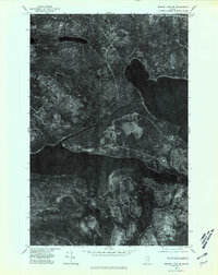
1975 Map of Square Lake SW
USGS Topo · Published 1981About this map
Square Lake and the eastern reach of Eagle Lake define this mid-1970s orthophoto, providing a photographic record of the North Maine Woods before modern developments changed the shoreline. Unlike traditional line-drawn maps, this survey uses rectified aerial photography to reveal the dense coniferous forest canopy and the precise patterns of timber harvesting across the Aroostook County interior. Small interior water bodies like California Pond and the drainage of Dimock Brook are visible amidst the timberlands, showing the complex hydrology of the region. The map preserves the exact state of logging roads and forest clearings as they existed during the 1975 flyover by the Geological Survey, offering a unique look at the industrial forest landscape of the late twentieth century.
Find a feature on this map
4 named features on this map. Tap any name to fly to it.
Don’t see what you’re looking for? This feature index may not catch every label — zoom into the map to look around manually.
Map Details
Editions of this 1975 Square Lake SW Map
This is the sole edition of this map. No revisions or reprints were ever made.
Other maps of this area

1927 · Square Lake
USGS Topo · 1:48,000

1928 · Eagle Lake
USGS Topo · 1:48,000

1928 · Winterville
USGS Topo · 1:48,000

1929 · Portage
USGS Topo · 1:62,500

1931 · Square Lake
USGS Topo · 1:62,500

1931 · Eagle Lake
USGS Topo · 1:62,500

1931 · Portage
USGS Topo · 1:62,500

1931 · Winterville
USGS Topo · 1:62,500

1953 · Square Lake
USGS Topo · 1:62,500

1953 · Portage
USGS Topo · 1:62,500