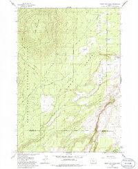
1985 Map of Squaw Back Ridge
USGS Topo · Published 1986About this map
Geneva (Site) sits at the edge of the Lower Desert in this mid-1980s landscape, marking a point of former settlement where Geneva Road meets the open range. The geography is defined by the steep descent toward the Crooked River along the eastern boundary, contrasted by the rising elevations of Squaw Back Ridge to the northwest. This transition between the high desert and the Deschutes National Forest reveals a ranching economy anchored by the Flying 8 Ranch and Rim Rock Ranch.
Find a feature on this map
27 named features on this map. Tap any name to fly to it.
Don’t see what you’re looking for? This feature index may not catch every label — zoom into the map to look around manually.
Map Details
Editions of this 1985 Squaw Back Ridge Map
This is the sole edition of this map. No revisions or reprints were ever made.
Other maps of this area

1926 · Bend
USGS Topo · 1:125,000

1927 · Mt. Jefferson
USGS Topo · 1:125,000

1928 · Madras
USGS Topo · 1:125,000

1929 · Bend
USGS Topo · 1:125,000

1929 · Three Sisters
USGS Topo · 1:125,000

1930 · Mt. Jefferson
USGS Topo · 1:125,000

1931 · Madras
USGS Topo · 1:125,000

1932 · Three Sisters
USGS Topo · 1:125,000

1955 · Bend
USGS Topo · 1:250,000

1957 · Bend
USGS Topo · 1:250,000