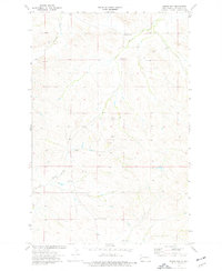
1974 Map of Squaw Gap
USGS Topo · Published 1977About this map
Squaw Gap and the surrounding badlands of McKenzie County are defined by a high-desert landscape of drainage creeks and intermittent springs. The map shows a rural settlement pattern centered on the small community of Squaw Gap, where the local Cemetery and nearby Spring Creek provided the essential points of navigation. To the south, the Plainview School and Sunny Side Cemetery suggest the locations of early 20th-century neighborhood hubs in this sparsely populated ranching country.
Find a feature on this map
11 named features on this map. Tap any name to fly to it.
Don’t see what you’re looking for? This feature index may not catch every label — zoom into the map to look around manually.
Map Details
Editions of this 1974 Squaw Gap Map
This is the sole edition of this map. No revisions or reprints were ever made.
Other maps of this area

1909 · Glendive
USGS Topo · 1:250,000

1953 · Watford City
USGS Topo · 1:250,000

1954 · Glendive
USGS Topo · 1:250,000

1957 · Glendive
USGS Topo · 1:250,000

1957 · Watford City
USGS Topo · 1:250,000

1958 · Glendive
USGS Topo · 1:250,000

1967 · Watford City
USGS Topo · 1:250,000

1972 · Sidney SE
USGS Topo · 1:24,000
1972 · Phillip Spring
USGS Topo · 1:24,000

1972 · Sheep Creek
USGS Topo · 1:24,000