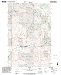
1997 Map of Squaw Gap
USGS Topo · Published 2001About this map
Little Missouri National Grassland dominates this McKenzie County landscape, where the intersection of ranching traditions and petroleum development defines the local economy during the late twentieth century. Family-held lands such as H Wheeling Ranch, Kupper HQ Ranch, and M-Leland Ranch are interspersed with the infrastructure of the Bicentennial Oil Field, reflecting the multi-use character of the North Dakota badlands. In the north, the small settlement of Squaw Gap serves as a local landmark near the headwaters of Spring Creek. Social and community history is preserved through the locations of rural infrastructure like the Plainview Sch and Sunny Side Cem. The presence of several Scoria Pits further indicates the geological resources utilized for road building and maintenance in this remote ranching district.
Find a feature on this map
21 named features on this map. Tap any name to fly to it.
Don’t see what you’re looking for? This feature index may not catch every label — zoom into the map to look around manually.
Map Details
Editions of this 1997 Squaw Gap Map
This is the sole edition of this map. No revisions or reprints were ever made.
Other maps of this area

1909 · Glendive
USGS Topo · 1:250,000

1953 · Watford City
USGS Topo · 1:250,000

1954 · Glendive
USGS Topo · 1:250,000

1957 · Glendive
USGS Topo · 1:250,000

1957 · Watford City
USGS Topo · 1:250,000

1958 · Glendive
USGS Topo · 1:250,000

1967 · Watford City
USGS Topo · 1:250,000

1972 · Sidney SE
USGS Topo · 1:24,000
1972 · Phillip Spring
USGS Topo · 1:24,000

1972 · Sheep Creek
USGS Topo · 1:24,000