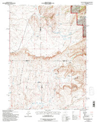
1992 Map of Squaw Spring
USGS Topo · Published 1996About this map
The Little Medicine Bow River winds through this high-elevation ranching landscape at the intersection of four Wyoming counties: Natrona, Converse, Carbon, and Albany. Cattle ranching and homesteading history are prominent here, with named sites like the Higginson Homestead, Eggleston Homestead, and the Taylor Ranch dotting the terrain. The presence of the Little Medicine Sch suggests a once-active rural school district serving these remote families.
Find a feature on this map
37 named features on this map. Tap any name to fly to it.
Don’t see what you’re looking for? This feature index may not catch every label — zoom into the map to look around manually.
Map Details
Editions of this 1992 Squaw Spring Map
This is the sole edition of this map. No revisions or reprints were ever made.
Other maps of this area

1954 · Torrington
USGS Topo · 1:250,000

1955 · Casper
USGS Topo · 1:250,000

1958 · Casper
USGS Topo · 1:250,000

1958 · Torrington
USGS Topo · 1:250,000

1959 · Moss Agate Reservoir
USGS Topo · 1:24,000

1959 · Squaw Spring
USGS Topo · 1:24,000

1959 · Chalk Hills
USGS Topo · 1:24,000

1959 · Bates Creek Reservoir
USGS Topo · 1:24,000

1960 · Ice Cave Mountain
USGS Topo · 1:24,000

1960 · Reno Hill
USGS Topo · 1:24,000