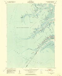
1952 Map of St. Clair Flats
USGS Topo · Published 1954About this map
Lake St Clair National Wildlife Refuge dominates the watery expanse of this coastal survey, where the international border between the United States and Canada cuts through the intricate marshlands of the St Clair River delta. The landscape is defined by a dense network of “highways” or water channels, such as Baltimore Highway and Chenal A Bout, which navigate around prominent landmasses like Dickinson Island and Harsens Island. This mid-century view shows the region's unique maritime character, where small settlements such as Riverside and landmarks like the Coast Guard Station serve as anchors within the shifting channels of Anchor Bay and Goose Bay. The proximity to the Walpole Island Indian Reserve across the border highlights the cross-border geography of the flats, where land and water are inextricably linked through cuts like Schweinkart Cut and local landmarks like Strawberry Island.
Find a feature on this map
80 named features on this map. Tap any name to fly to it.
Don’t see what you’re looking for? This feature index may not catch every label — zoom into the map to look around manually.
Map Details
Editions of this 1952 St. Clair Flats Map
This is the sole edition of this map. No revisions or reprints were ever made.
Other maps of this area

1905 · Grosse Pointe
USGS Topo · 1:62,500

1912 · Mt Clemens
USGS Topo · 1:62,500

1914 · Algonac
USGS Topo · 1:62,500

1918 · Grosse Pointe
USGS Topo · 1:62,500

1929 · Mt Clemens
USGS Topo · 1:62,500

1936 · New Haven
USGS Topo · 1:31,680

1936 · Selfridge Field
USGS Topo · 1:31,680

1936 · New Baltimore
USGS Topo · 1:31,680

1936 · Algonac
USGS Topo · 1:31,680

1939 · New Baltimore
USGS Topo · 1:24,000