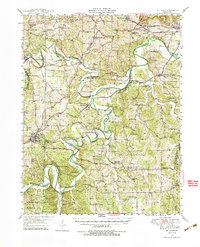
1947 Map of St. Clair
USGS Topo · Published 1994About this map
The Bourbeuse River and Meramec River meander through this postwar Missouri landscape, defining the rural character of Franklin and Jefferson Counties. At this time, the region was characterized by small agricultural communities and an educational network of country schoolhouses like Pikes Peak Sch and Rye Creek Sch. The industrial and commercial footprint is seen at The Diamonds and the Purina Farm, while the ST Louis - San Francisco railroad provides the primary transit artery alongside U.S. 66. Local history is deeply embedded in the numerous family cemeteries such as Ekey Cem and landmark institutions like the Henry Shaw Arboretum. The presence of Virginia Mines (Abandoned) south of St Clair points to a previous era of resource extraction that had already begun to fade by the late 1940s.
Find a feature on this map
81 named features on this map. Tap any name to fly to it.
Don’t see what you’re looking for? This feature index may not catch every label — zoom into the map to look around manually.
Map Details
Editions of this 1947 St. Clair Map
3 editions found

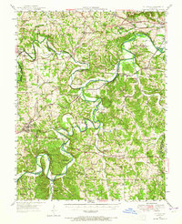
Other maps of this area

1890 · Hermann
USGS Topo · 1:125,000

1901 · De Soto
USGS Topo · 1:125,000

1903 · O'Fallon
USGS Topo · 1:125,000

1903 · Sullivan
USGS Topo · 1:125,000

1934 · Meramec State Park
USGS Topo · 1:24,000

1937 · Pacific
USGS Topo · 1:24,000

1937 · Fletcher
USGS Topo · 1:24,000

1937 · Meramec State Park
USGS Topo · 1:24,000

1938 · Cedar Hill
USGS Topo · 1:24,000

1938 · Fletcher
USGS Topo · 1:24,000