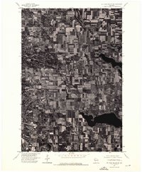
1974 Map of St. Croix Dalles NE
USGS Topo · Published 1976About this map
Centrally positioned in this 1974 orthophotograph, the village of Centuria serves as the primary focal point of a landscape defined by an intensive agricultural grid. Unlike a traditional topographic map, this aerial-based survey provides a photographic record of land use in Polk County, revealing the distinct patchwork of cultivated fields and wooded lot lines that characterized northwestern Wisconsin during the mid-1970s. The village itself is tightly clustered around a clear north-south corridor and a diagonal rail line, showing the classic Midwestern layout where residential and commercial activity centers on transportation routes. Several large water bodies are visible across the southern and eastern portions of the quadrangle, their dark, irregular shapes contrasting sharply with the geometric precision of the surrounding farms.
Find a feature on this map
1 named feature on this map. Tap any name to fly to it.
Don’t see what you’re looking for? This feature index may not catch every label — zoom into the map to look around manually.
Map Details
Editions of this 1974 St. Croix Dalles NE Map
This is the sole edition of this map. No revisions or reprints were ever made.
Other maps of this area

1900 · St Croix Dalles
USGS Topo · 1:62,500

1901 · St Croix Dalles
USGS Topo · 1:62,500

1950 · Balsam Lake
USGS Topo · 1:62,500

1951 · Milltown
USGS Topo · 1:48,000

1951 · Frederic
USGS Topo · 1:48,000

1953 · Stillwater
USGS Topo · 1:250,000

1955 · St. Croix Dalles
USGS Topo · 1:62,500

1955 · Frederic
USGS Topo · 1:62,500

1955 · Milltown
USGS Topo · 1:62,500

1955 · Stillwater
USGS Topo · 1:250,000