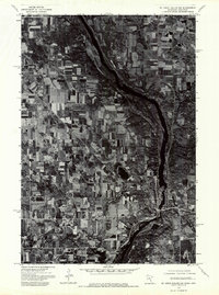
1974 Map of St Croix Dalles NW
USGS Topo · Published 1976About this map
The St Croix River carves a deep valley through this landscape, serving as the natural boundary between Minnesota and Wisconsin. This 1974 orthophotoquad provides a clear visual record of the rural agricultural patterns and dense woodlands that characterized the region in the mid-1970s. The neighboring settlements of St Croix Falls and Taylors Falls are situated at a prominent bend in the river, where the terrain shifts from open fields to steeper, more rugged riverbanks. These communities developed at a critical point of river navigation and industry, and their street grids and early infrastructure are visible against the backdrop of the surrounding farmland and the winding river channel.
Find a feature on this map
3 named features on this map. Tap any name to fly to it.
Don’t see what you’re looking for? This feature index may not catch every label — zoom into the map to look around manually.
Map Details
Editions of this 1974 St Croix Dalles NW Map
This is the sole edition of this map. No revisions or reprints were ever made.
Other maps of this area

1900 · St Croix Dalles
USGS Topo · 1:62,500

1901 · St Croix Dalles
USGS Topo · 1:62,500

1950 · Rush City
USGS Topo · 1:48,000

1951 · Milltown
USGS Topo · 1:48,000

1953 · Stillwater
USGS Topo · 1:250,000

1955 · St. Croix Dalles
USGS Topo · 1:62,500

1955 · Rush City
USGS Topo · 1:62,500

1955 · Milltown
USGS Topo · 1:62,500

1955 · Forest Lake
USGS Topo · 1:62,500

1955 · Stillwater
USGS Topo · 1:250,000