
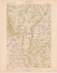
1919 Map of St. Francis
USGS Topo · Published 1919About this map
The Rum River meanders sharply through the heart of this central Minnesota landscape, serving as a corridor for early 20th-century settlement between Saint Francis and the northern reaches of Grow. The area is densely patterned with rural institutions, including a high concentration of numbered school districts and named facilities like the Lakeside School, Dunn School, and Breezy Point School. The terrain is characterized by a high density of glacial basins, ranging from the prominent Lake George and Lake Itasca to smaller water bodies such as Shack Eddy Lake and Pinnaker Lake. The eastern edge of the quadrangle is defined by the Great Northern railroad line, which connects the villages of Bethel, Cedar, and Constance, illustrating the rail-driven development of Isanti and Anoka counties during this era.
Find a feature on this map
73 named features on this map. Tap any name to fly to it.
Don’t see what you’re looking for? This feature index may not catch every label — zoom into the map to look around manually.
Map Details
Editions of this 1919 St. Francis Map
2 editions found
Other maps of this area

1902 · White Bear
USGS Topo · 1:62,500

1902 · Anoka
USGS Topo · 1:62,500

1909 · Rockford
USGS Topo · 1:62,500

1916 · St. Francis
USGS Topo · 1:62,500

1953 · Stillwater
USGS Topo · 1:250,000

1955 · Circle Pines
USGS Topo · 1:24,000

1955 · Anoka
USGS Topo · 1:24,000

1955 · Coon Rapids
USGS Topo · 1:24,000

1955 · Isanti
USGS Topo · 1:62,500

1955 · Anoka
USGS Topo · 1:62,500