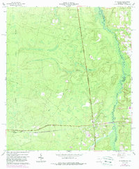
1966 Map of St George
USGS Topo · Published 1988About this map
Trail Ridge dominates the western landscape of this Charlton County area, marking a significant geological boundary as the St Marys River defines the winding border between Georgia and Florida. The settlement of St George serves as the local hub, supported by community landmarks such as St George Cemetery and Conner Green Cem. The map reveals a landscape defined by water and timber transport, with Boone Creek and Deep Creek draining the lowlands toward the river. An Old Railroad Grade cutting through the center and a prominent Lookout Tower near the small community of Clarking highlight the historical importance of the local forestry industry and rail connectivity. This 1960s survey, with later 1980s updates, captures the rural character of the region before significant modern development, preserving the locations of rural congregations like Boone Creek Ch.
Find a feature on this map
16 named features on this map. Tap any name to fly to it.
Don’t see what you’re looking for? This feature index may not catch every label — zoom into the map to look around manually.
Map Details
Editions of this 1966 St George Map
3 editions found
Other maps of this area

1917 · Cambon
USGS Topo · 1:62,500

1917 · Macclenny
USGS Topo · 1:62,500

1917 · Hilliard
USGS Topo · 1:62,500

1918 · Moniac
USGS Topo · 1:62,500

1918 · Cambon
USGS Topo · 1:62,500

1918 · Macclenny
USGS Topo · 1:62,500

1919 · Hilliard
USGS Topo · 1:62,500

1942 · Moniac
USGS Topo · 1:62,500

1948 · Jacksonville
USGS Topo · 1:250,000

1954 · Valdosta
USGS Topo · 1:250,000