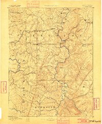
1891 Map of St. George
USGS Topo · Published 1900About this map
Trowbridge Ferry provides a crossing point over the Cheat River in this survey of the rugged northern West Virginia highlands, conducted by Henry Gannett and Gilbert Thompson between 1883 and 1885. The landscape is defined by the steep elevation of Great Backbone Mountain and the Laurel Hills, where narrow valleys dictate the paths of early infrastructure. The Baltimore and Ohio Railroad cuts through the mountains via Tunnelton and Rowlesburg, while the Grafton and Belington Railroad follows the Tygart Valley River in the west. These rail lines connected industrial outposts like Valley Furnace and Newburg to the regional economy. Settlements like St George and Kingwood stand as established hubs among a network of smaller farming and mining communities, including New Interest and Fellowsville, which are deeply intertwined with the winding runs and creeks that feed the Cheat and Monongahela watersheds.
Find a feature on this map
97 named features on this map. Tap any name to fly to it.
Don’t see what you’re looking for? This feature index may not catch every label — zoom into the map to look around manually.
Map Details
Editions of this 1891 St. George Map
3 editions found
Other maps of this area

1886 · St. George
USGS Topo · 1:125,000

1889 · Beverly
USGS Topo · 1:125,000

1891 · St. George
USGS Topo · 1:125,000

1892 · Beverly
USGS Topo · 1:125,000

1892 · Franklin
USGS Topo · 1:125,000

1893 · Buckhannon
USGS Topo · 1:125,000

1895 · Piedmont
USGS Topo · 1:125,000

1896 · Buckhannon
USGS Topo · 1:125,000

1896 · Franklin
USGS Topo · 1:125,000

1897 · Buckhannon
USGS Topo · 1:125,000