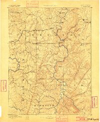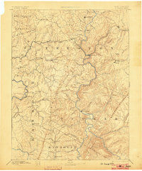
1891 Map of St. George
USGS Topo · Published 1903About this map
Kingwood and St. George anchor this survey of the Alleghenies during a period of expanding timber and rail influence. The intricate topography is defined by the Backbone Mountain and Shavers Mountain ranges, with the Baltimore and Ohio Railroad cutting a vital corridor through Tunnelton and Rowlesburg. A historical industrial presence is marked at Valley Furnace in Barbour County, while Trowbridge Ferry provides a specific point of river transit before modern bridges dominated the Cheat River drainage. The map details a network of small settlements such as Fellowsville, Nestorville, and Moatsville connected by winding mountain roads and numerous runs. Waterways like the Black Water River and Shafers Fork illustrate the complex drainage patterns that dictated early settlement and movement through this section of the West Virginia highlands.
Find a feature on this map
76 named features on this map. Tap any name to fly to it.
Don’t see what you’re looking for? This feature index may not catch every label — zoom into the map to look around manually.
Map Details
Editions of this 1891 St. George Map
3 editions found