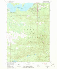
1965 Map of St. Helen
USGS Topo · Published 1982About this map
Lake St Helen anchors this mid-century look at Roscommon County, where the community of St Helen sits at the junction of the New York Central Railroad and several historic logging grades. To the west, the developed shoreline at Artesia Beach gives way to the dense woodlands of the Au Sable State Forest. The map captures an era of transition as the timber economy's legacy is visible in the numerous segments of Old Railroad Grade that lattice the landscape, now serving as access for recreation and fire management, evidenced by the Indian Springs Lookout Tower. Genealogists will find the locations of Fairview Cem and Maple Valley Cem near the southern settlement of Maple Valley, while aviation history is noted at the St Helen Landing Field. The terrain is defined by low-lying glacial features including Fisher Lake and the marshy basins of Indian Lake and Ninemile Lake.
Find a feature on this map
35 named features on this map. Tap any name to fly to it.
Don’t see what you’re looking for? This feature index may not catch every label — zoom into the map to look around manually.
Map Details
Editions of this 1965 St. Helen Map
2 editions found
Other maps of this area

1954 · Traverse City
USGS Topo · 1:250,000

1958 · Traverse City
USGS Topo · 1:250,000

1963 · Roscommon South
USGS Topo · 1:24,000

1963 · Backus Lake
USGS Topo · 1:24,000

1965 · St. Helen NW
USGS Topo · 1:24,000

1965 · St. Helen NE
USGS Topo · 1:24,000

1965 · St. Helen
USGS Topo · 1:24,000

1965 · Ogemaw Springs
USGS Topo · 1:24,000

1969 · Meredith
USGS Topo · 1:24,000

1969 · Edwards
USGS Topo · 1:24,000