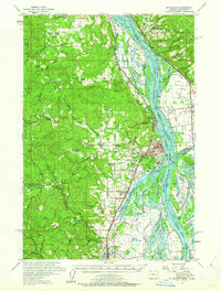
1954 Map of St Helens
USGS Topo · Published 1962About this map
The Columbia River serves as the dominant artery of this mid-century survey, defining the industrial and agricultural corridors of Columbia County. This map documents a landscape heavily influenced by the timber and transport sectors, centered on the growing riverfront hub of St Helens and the nearby community of Columbia City. The intersection of water and rail is evident in the presence of the Spokane Portland and Seattle Railway and the Northern Pacific Railway, which facilitated the movement of goods through settlements like Goble and Scappoose. Inland, the terrain rises toward Strawberry Ridge, where the Wilark Guard Station and Meissner Lookout reflect the region's managed forests. Notable for local history and genealogy are several vanished or shifted educational sites, including the Dowd School and the Shiloh Basin School, alongside family-named landmarks like McBride School and Yankton School.
Find a feature on this map
113 named features on this map. Tap any name to fly to it.
Don’t see what you’re looking for? This feature index may not catch every label — zoom into the map to look around manually.
Map Details
Editions of this 1954 St Helens Map
2 editions found
Other maps of this area

1897 · Portland
USGS Topo · 1:62,500

1905 · Portland
USGS Topo · 1:62,500

1915 · Hillsboro
USGS Topo · 1:62,500

1918 · Hillsboro
USGS Topo · 1:62,500

1919 · Mayger
USGS Topo · 1:62,500

1921 · Kalama
USGS Topo · 1:62,500

1922 · St. Helens
USGS Topo · 1:62,500

1940 · Hillsboro
USGS Topo · 1:62,500

1940 · Portland
USGS Topo · 1:62,500

1940 · La Center
USGS Topo · 1:62,500