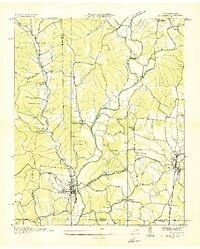
1936 Map of St. Joseph
USGS Topo · Published 1936About this map
Iron City and St. Joseph anchor this 1936 survey, revealing a landscape defined by the industrial and transport infrastructure of the mid-1930s. The Louisville and Nashville Company railroad winds through the terrain, connecting small settlements like Corning and Hardwick while a narrow gage line branches off near the Tennessee-Alabama border. The rural economy is evident in the presence of the Wolf Creek Mill and several mines, though many are already marked as Mine (Abandoned).
Find a feature on this map
48 named features on this map. Tap any name to fly to it.
Don’t see what you’re looking for? This feature index may not catch every label — zoom into the map to look around manually.
Map Details
Editions of this 1936 St. Joseph Map
This is the sole edition of this map. No revisions or reprints were ever made.
Other maps of this area

1905 · Waynesboro
USGS Topo · 1:125,000

1914 · Rogersville
USGS Topo · 1:48,000

1914 · Muscle Shoals
USGS Topo · 1:48,000

1916 · Muscle Shoals
USGS Topo · 1:62,500

1916 · Rogersville
USGS Topo · 1:62,500

1936 · Westpoint
USGS Topo · 1:24,000

1936 · Collinwood
USGS Topo · 1:24,000

1936 · Light
USGS Topo · 1:24,000

1936 · Long Branch
USGS Topo · 1:24,000

1936 · Loretto
USGS Topo · 1:24,000