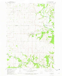
1981 Map of St. Lucas
USGS Topo · Published 1982About this map
St Lucas serves as the central hub of this agricultural landscape along the border of Winneshiek and Fayette Counties. The terrain is deeply carved by the Turkey River and Little Turkey River, creating a winding network of valleys and bluffs. Local religious and community life is anchored by landmarks like the St Anthony of Padua Chapel and the small Eden Cem, while recreational space is preserved at Gouldsburg County Park near the confluence of the river and Crane Creek. The map documents a rural Iowa economy heavily reliant on the land, evidenced by numerous quarries and sandpits interspersed between the townships of Jackson, Washington, Eden, and Auburn. Fine red dashed lines throughout the survey delineate field boundaries and fence lines as they appeared during the late 1970s photogrammetric check.
Find a feature on this map
19 named features on this map. Tap any name to fly to it.
Don’t see what you’re looking for? This feature index may not catch every label — zoom into the map to look around manually.
Map Details
Editions of this 1981 St. Lucas Map
This is the sole edition of this map. No revisions or reprints were ever made.
Other maps of this area

1901 · Oelwein
USGS Topo · 1:125,000

1906 · Decorah
USGS Topo · 1:125,000

1954 · Mason City
USGS Topo · 1:250,000

1954 · Waterloo
USGS Topo · 1:250,000

1955 · Waterloo
USGS Topo · 1:250,000

1957 · Mason City
USGS Topo · 1:250,000

1958 · Mason City
USGS Topo · 1:250,000

1958 · La Crosse
USGS Topo · 1:250,000

1959 · Dubuque
USGS Topo · 1:250,000

1961 · Dubuque
USGS Topo · 1:250,000