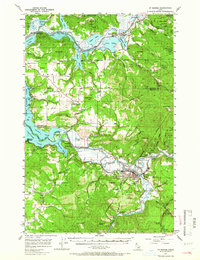
1957 Map of St. Maries
USGS Topo · Published 1966About this map
The confluence of the St Joe River and the Coeur d'Alene River defines this mid-century landscape in the Idaho Panhandle. At the heart of the region, St Maries serves as a hub for both river and rail transport, situated where the Chicago Milwaukee St Paul and Pacific tracks follow the river's bend. The map illustrates a complex network of wetlands and lateral lakes including Anderson Lake, Black Lake, and the aptly named Goose Heaven Lake, reflecting the hydrological character of the valley before modern alterations.
Find a feature on this map
62 named features on this map. Tap any name to fly to it.
Don’t see what you’re looking for? This feature index may not catch every label — zoom into the map to look around manually.
Map Details
Editions of this 1957 St. Maries Map
3 editions found
Other maps of this area

1903 · Rathdrum
USGS Topo · 1:125,000

1909 · Cataldo
USGS Topo · 1:125,000

1911 · Cataldo
USGS Topo · 1:125,000

1950 · Rochat Peak
USGS Topo · 1:24,000

1952 · Rochat Peak
USGS Topo · 1:24,000

1955 · Spokane
USGS Topo · 1:250,000

1957 · St. Maries
USGS Topo · 1:62,500

1957 · Kingston
USGS Topo · 1:62,500

1957 · Emida
USGS Topo · 1:62,500

1957 · Plummer
USGS Topo · 1:62,500