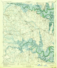
1919 Map of St Marys
USGS Topo · Published 1936About this map
The St Marys waterfront and the surrounding coastal marshlands of Nassau County define this landscape just after the first World War. The region relies heavily on water-based transport and the Seaboard Air Line railway, which connects inland points like Gross and Becker to the coast. This era shows a network of family-named river landings, such as Deese Landing, Joels Landing, and Seaton Landing, indicating a time when the Nassau River and St Marys River were vital arteries for movement and commerce before modern road development took hold. Social life in the outlying rural districts is anchored by a series of numbered and named schoolhouses, including Italia School, Evergreen School, and Holly Grove School. Large swaths of the terrain consist of expansive wetlands like Mc Queen Swamp and Plummer Swamp, illustrating the natural obstacles faced by early settlers in the Florida-Georgia borderlands.
Find a feature on this map
70 named features on this map. Tap any name to fly to it.
Don’t see what you’re looking for? This feature index may not catch every label — zoom into the map to look around manually.
Map Details
Editions of this 1919 St Marys Map
5 editions found

Other maps of this area

1917 · Cambon
USGS Topo · 1:62,500

1917 · Boulogne
USGS Topo · 1:62,500

1917 · Hilliard
USGS Topo · 1:62,500

1918 · St Marys
USGS Topo · 1:62,500

1918 · Cumberland Island
USGS Topo · 1:62,500

1918 · Cambon
USGS Topo · 1:62,500

1918 · Jacksonville
USGS Topo · 1:62,500

1918 · Kingsland
USGS Topo · 1:62,500

1918 · Mayport
USGS Topo · 1:62,500

1919 · Fernandina
USGS Topo · 1:62,500