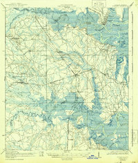
1919 Map of St Marys
USGS Topo · Published 1944About this map
The St Marys River snakes along the state border in this 1917–1918 survey, defining a landscape of tidal creeks and dense wetlands between Georgia and Florida. This era captures the critical infrastructure of the coastal plain before modern development, where transit relied heavily on the Seaboard Air Line and the Atlantic Waycross and Northern railroads. Interior settlements like Evergreen and Italia are centered around local institutions such as the Evergreen School and Italia School, while the riverfront is dotted with family-named landings like Joels Landing and Vaughn Landing. The intricate network of waterways, including Mc Queen Swamp and Plummers Swamp, illustrates the complex drainage of the region into the Nassau River. Local genealogists will find value in the precise location of schoolhouses and small communities such as Nassauville and Gross that served these rural maritime and rail-based economies.
Find a feature on this map
76 named features on this map. Tap any name to fly to it.
Don’t see what you’re looking for? This feature index may not catch every label — zoom into the map to look around manually.
Map Details
Editions of this 1919 St Marys Map
5 editions found

Other maps of this area

1917 · Cambon
USGS Topo · 1:62,500

1917 · Boulogne
USGS Topo · 1:62,500

1917 · Hilliard
USGS Topo · 1:62,500

1918 · St Marys
USGS Topo · 1:62,500

1918 · Cumberland Island
USGS Topo · 1:62,500

1918 · Cambon
USGS Topo · 1:62,500

1918 · Jacksonville
USGS Topo · 1:62,500

1918 · Kingsland
USGS Topo · 1:62,500

1918 · Mayport
USGS Topo · 1:62,500

1919 · Fernandina
USGS Topo · 1:62,500