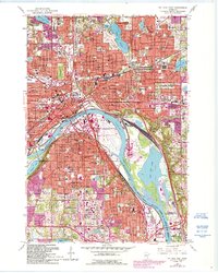
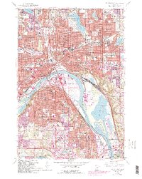
1967 Map of St Paul East
USGS Topo · Published 1993About this map
The Mississippi River carves a deep arc through this urban landscape, defining the industrial and civic heart of St Paul during the late twentieth century. This survey documents the dense concentration of religious and educational institutions that anchored these neighborhoods, including the iconic St Paul Cathedral and numerous parochial schools like St Joseph Sch and St Michael Sch. The riverfront itself is a hub of activity, featuring the Paul Downtown Airport (Holman Field) situated on a large bend across from Harriet Island. To the north and east, the transition into Maplewood and Roseville is marked by expansive green spaces and water bodies, most notably Phalen Lake and the historic Oakland Cemetery. The presence of the Chicago and North Western rail line and major thoroughfares like Warner Road illustrate the city's role as a regional transportation nexus, while the sprawling Pigs Eye Lake dominates the southeastern quadrant.
Find a feature on this map
86 named features on this map. Tap any name to fly to it.
Don’t see what you’re looking for? This feature index may not catch every label — zoom into the map to look around manually.
Map Details
Editions of this 1967 St Paul East Map
5 editions found
Other maps of this area

1896 · St. Paul
USGS Topo · 1:62,500

1902 · White Bear
USGS Topo · 1:62,500

1946 · Hudson
USGS Topo · 1:62,500

1948 · Stillwater
USGS Topo · 1:62,500

1949 · Hudson
USGS Topo · 1:62,500

1949 · Stillwater
USGS Topo · 1:62,500

1949 · Lake Elmo
USGS Topo · 1:24,000

1950 · Lake Elmo
USGS Topo · 1:24,000

1950 · St Paul Park
USGS Topo · 1:24,000

1951 · St Paul Park
USGS Topo · 1:24,000