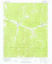
1973 Map of St. Paul
USGS Topo · Published 1976About this map
The White River carves a deep valley through the mountain landscape of southern Madison County, anchoring the settlements of Combs and St Paul. During the early 1970s, this area of the Ozark National Forest maintained a network of small upland communities and family landmarks, many established along the tributaries of Greasy Creek and Fleming Creek. The map provides significant genealogical value, documenting numerous burial sites such as Riverside Cem, Prater Cem, and Mill Creek Cem that served these isolated hollows. Upland terrain is dominated by high ridges and knobs, including Mahaffey Knob and Chimney Rock Mtn, while the Fly Gap Lookout Tower stands as a sentinel over the southern heights near the Madison and Franklin County line. The distribution of these named features reflects a history of subsistence mountain farming and forestry in the Ozark interior.
Find a feature on this map
66 named features on this map. Tap any name to fly to it.
Don’t see what you’re looking for? This feature index may not catch every label — zoom into the map to look around manually.
Map Details
Editions of this 1973 St. Paul Map
4 editions found
Other maps of this area

1879 · Cravens
USGS Topo · 1:62,500

1887 · Watalula
USGS Topo · 1:62,500

1906 · Batson
USGS Topo · 1:62,500

1939 · Watalula
USGS Topo · 1:62,500

1943 · St. Paul
USGS Topo · 1:62,500

1946 · St. Paul
USGS Topo · 1:62,500

1956 · Russellville
USGS Topo · 1:250,000

1964 · Russellville
USGS Topo · 1:250,000
1973 · Witter
USGS Topo · 1:24,000
1973 · Durham
USGS Topo · 1:24,000