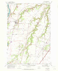
1956 Map of St. Paul
USGS Topo · Published 1971About this map
The Willamette River defines the western edge of this agricultural landscape in northern Marion County, where the historic settlement of St Paul serves as a central hub. Revised in 1970, the map illustrates a region defined by fertile French Prairie lands and complex drainage systems like Champoeg Creek, which meanders through the heart of the quadrangle toward the old site of Champoeg. The transport evolution of the valley is evident, contrasting the legacy of river landings like Mission Bar and Ray Bar with the modern path of the Baldock Freeway and the rail lines of the Oregon Electric. Small community anchors remain prominent, including the St Louis School and Fairfield Cemetery, alongside the edge of growing Woodburn. The terrain transition between the river bottoms and the upland orchards is marked by features like Horseshoe Lake and numerous local thoroughfares including Mission Road and St Paul-Fairfield Road.
Find a feature on this map
43 named features on this map. Tap any name to fly to it.
Don’t see what you’re looking for? This feature index may not catch every label — zoom into the map to look around manually.
Map Details
Editions of this 1956 St. Paul Map
4 editions found
Other maps of this area

1916 · Tualatin
USGS Topo · 1:62,500

1923 · Mount Angel
USGS Topo · 1:62,500

1924 · Mc Minnville
USGS Topo · 1:48,000

1926 · Mc Minnville
USGS Topo · 1:62,500

1939 · Tualatin
USGS Topo · 1:62,500

1940 · McMinnville
USGS Topo · 1:62,500

1940 · Tualatin
USGS Topo · 1:62,500

1940 · Mount Angel
USGS Topo · 1:62,500

1941 · Yamhill
USGS Topo · 1:62,500

1942 · Yamhill
USGS Topo · 1:62,500