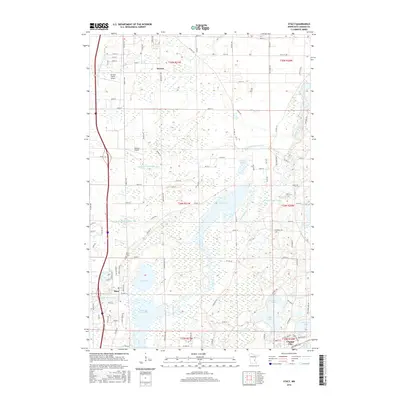
2016 Map of Stacy
USGS Topo · Published 2016About this map
Stacy serves as a central hub for this portion of Chisago County, situated amidst a complex network of waterways and drainage systems. The landscape is defined by the Sunrise River and its multiple impoundments, including Sunrise River Pool 1 and Sunrise River Pool 3, which reflect the extensive hydrological management of the region. This is further evidenced by a series of numbered man-made channels like County Ditch Number Ten and County Ditch Number Five that crisscross the low-lying terrain. Local aviation is represented by Al's Due North Airport and Bowers Airport, while the Stacy Cem provides a point of interest for genealogists. The map also captures the northern edge of Chisago City and the dispersed settlement of Branch, showcasing the transition from small-town centers to a wetland-rich rural interior containing Mud Lake and School Lake.
Find a feature on this map
89 named features on this map. Tap any name to fly to it.
Don’t see what you’re looking for? This feature index may not catch every label — zoom into the map to look around manually.
Map Details
Editions of this 2016 Stacy Map
This is the sole edition of this map. No revisions or reprints were ever made.
Other maps of this area

1950 · Rush City
USGS Topo · 1:48,000

1953 · Stillwater
USGS Topo · 1:250,000

1955 · Rush City
USGS Topo · 1:62,500

1955 · Forest Lake
USGS Topo · 1:62,500

1955 · Isanti
USGS Topo · 1:62,500

1955 · Stillwater
USGS Topo · 1:250,000

1958 · Stillwater
USGS Topo · 1:250,000

1961 · Cambridge
USGS Topo · 1:62,500

1965 · Stillwater
USGS Topo · 1:250,000
1974 · Stacy
USGS Topo · 1:24,000