
1948 Map of Stady
USGS Topo · Published 1948About this map
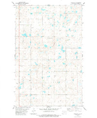
The Bureau of Reclamation and Geological Survey collaborated on this study of Northwest North Dakota just after the war, detailing the high plains topography at the border of Divide and Williams Counties. Small rural social centers are the primary landmarks in this sparsely populated landscape, including the settlement of Stady and several country schoolhouses such as School No. 1, Elmgren No. 2 Sch, and Sioux Trail Sch. Local congregation history is centered at Rudser Ch in the southern portion of the sheet. The terrain is defined by the glacial potholes and rises of the Missouri Coteau, prominently featuring the Smoky Butte landmark and the elevations of the Blue Ridge along the southern edge of the quadrangle.
Find a feature on this map
15 named features on this map. Tap any name to fly to it.
Don’t see what you’re looking for? This feature index may not catch every label — zoom into the map to look around manually.
Map Details
Editions of this 1948 Stady Map
This is the sole edition of this map. No revisions or reprints were ever made.
Other maps of this area

1948 · Smoky Butte
USGS Topo · 1:24,000

1948 · Hanks
USGS Topo · 1:24,000

1948 · Zahl
USGS Topo · 1:24,000

1953 · Williston
USGS Topo · 1:250,000

1957 · Williston
USGS Topo · 1:250,000

1977 · Appam
USGS Topo · 1:24,000

1983 · Writing Rock North
USGS Topo · 1:24,000

1983 · Alexandria
USGS Topo · 1:24,000

1983 · Writing Rock South
USGS Topo · 1:24,000
1983 · Colgan SE
USGS Topo · 1:24,000