
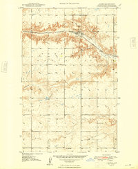
1948 Map of Hanks
USGS Topo · Published 1948About this map
The town of Hanks serves as the focal point for this late-1940s survey of Williams County, situated along the Great Northern railroad line. The map highlights a rural economy transitioning between the northern prairie's agricultural roots and its mineral potential, evidenced by the Bobittz Mine and Erke Mine positioned north of the rail corridor. Local education and community structures are well-preserved in this record, showing the locations of School No 2, Poling Sch, and Eureka No 2 Sch across the open landscape. Topographical interest is found in the steep draws leading into Scoria Creek and the prominence of Barr Butte. For genealogists, the inclusion of the Hanks Cem and Gladys Cem provides essential location data for early family sites in these townships.
Find a feature on this map
17 named features on this map. Tap any name to fly to it.
Don’t see what you’re looking for? This feature index may not catch every label — zoom into the map to look around manually.
Map Details
Editions of this 1948 Hanks Map
2 editions found
Other maps of this area

1948 · Grenora
USGS Topo · 1:24,000

1948 · Stady
USGS Topo · 1:24,000

1948 · Zahl
USGS Topo · 1:24,000

1953 · Williston
USGS Topo · 1:250,000

1957 · Williston
USGS Topo · 1:250,000

1974 · Blacktail Lake
USGS Topo · 1:24,000

1974 · Bonetraill
USGS Topo · 1:24,000

1974 · West Bonetraill
USGS Topo · 1:24,000

1983 · Writing Rock South
USGS Topo · 1:24,000
1983 · Williston
USGS Topo · 1:100,000