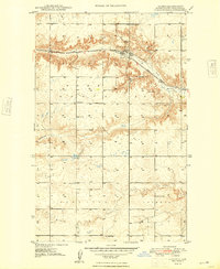
1948 Map of Hanks
USGS Topo · Published 1948About this map
The settlement of Hanks serves as a focal point in this northwestern North Dakota landscape, situated along the Great Northern railroad line just after World War II. The terrain is characterized by a series of distinct topographic features, including the Buttes, Scorio, and Goodluck formations, which reflect the region's complex geological history and drainage into Scorio Creek. Resource extraction is evident through the presence of the Bublitz Mine and Erke Mine, indicating the coal or mineral interests that supported the local economy during this era.
Find a feature on this map
18 named features on this map. Tap any name to fly to it.
Don’t see what you’re looking for? This feature index may not catch every label — zoom into the map to look around manually.
Map Details
Editions of this 1948 Hanks Map
2 editions found
Other maps of this area

1948 · Grenora
USGS Topo · 1:24,000

1948 · Hanks
USGS Topo · 1:24,000

1948 · Stady
USGS Topo · 1:24,000

1948 · Zahl
USGS Topo · 1:24,000

1953 · Williston
USGS Topo · 1:250,000

1957 · Williston
USGS Topo · 1:250,000

1974 · Blacktail Lake
USGS Topo · 1:24,000

1974 · Bonetraill
USGS Topo · 1:24,000

1974 · West Bonetraill
USGS Topo · 1:24,000

1983 · Writing Rock South
USGS Topo · 1:24,000