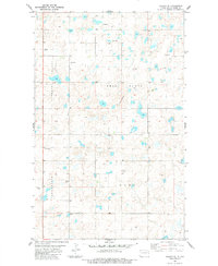
1983 Map of Colgan SE
USGS Topo · Published 1984About this map
Lincoln Valley and the elevated terrain of Twin Butte dominate this rural landscape of Divide County in the early 1980s. The map illustrates a remote prairie environment where human presence is marked by isolated Storage Bins and religious landmarks like Twin Butte Ch and Trinity Ch. The township of Alexandria and the locality of Burg are depicted within a grid of section lines and unimproved roads, reflecting the agricultural character of the High Plains. Small glacial wetlands or potholes are scattered throughout, typical of the regional topography. A small Cem and local Gravel Pits provide specific points of interest for genealogists and local historians documenting the physical development of this corner of North Dakota.
Find a feature on this map
12 named features on this map. Tap any name to fly to it.
Don’t see what you’re looking for? This feature index may not catch every label — zoom into the map to look around manually.
Map Details
Editions of this 1983 Colgan SE Map
This is the sole edition of this map. No revisions or reprints were ever made.
Other maps of this area

1948 · Smoky Butte
USGS Topo · 1:24,000

1948 · Crosby SW
USGS Topo · 1:24,000

1948 · Ambrose
USGS Topo · 1:24,000

1948 · Stady
USGS Topo · 1:24,000

1948 · Bright Water Lake
USGS Topo · 1:24,000

1950 · Crosby
USGS Topo · 1:62,500

1953 · Williston
USGS Topo · 1:250,000

1957 · Williston
USGS Topo · 1:250,000

1983 · Colgan West
USGS Topo · 1:24,000

1983 · Alexandria
USGS Topo · 1:24,000