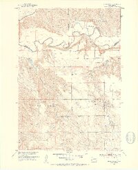
1951 Map of Stamford SE
USGS Topo · Published 1953About this map
The White River meanders sharply through this landscape of the Missouri River Basin, defining the boundary lines between Jackson, Jones, and Mellette counties. In the early 1950s, this area of South Dakota was characterized by a network of isolated homesteads and community centers like St James Ch and the Harmony Sch. The northern portion of the map is dominated by the Chicago Milwaukee St Paul and Pacific railroad, which follows the breaks above the river valley.
Find a feature on this map
22 named features on this map. Tap any name to fly to it.
Don’t see what you’re looking for? This feature index may not catch every label — zoom into the map to look around manually.
Map Details
Editions of this 1951 Stamford SE Map
3 editions found
Other maps of this area

1951 · Stamford SW
USGS Topo · 1:24,000

1951 · Stamford SE
USGS Topo · 1:24,000

1951 · Cedar Butte NW
USGS Topo · 1:24,000

1951 · Cedar Butte NE
USGS Topo · 1:24,000

1951 · Okaton SW
USGS Topo · 1:24,000

1951 · Murdo 3 NW
USGS Topo · 1:24,000

1955 · Martin
USGS Topo · 1:250,000

1958 · Martin
USGS Topo · 1:250,000

1972 · Okaton
USGS Topo · 1:24,000

1972 · Stamford NW
USGS Topo · 1:24,000