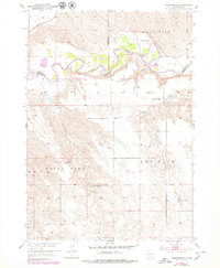
1951 Map of Stamford SE
USGS Topo · Published 1979About this map
The meandering White River carves a complex path through the South Dakota landscape at the junction of Jackson, Jones, and Mellette counties. In the early 1950s, this region was defined by its cattle ranching heritage, with prominent family operations like Perault Ranch, Vohr Ranch, and Hathaway Ranch established across the high plains and river breaks. The transportation corridor of the Chicago Milwaukee St Paul and Pacific railroad clips the northwestern corner, providing a vital link for the isolated ranching communities. Central to the local community was the Harmony Sch, situated near Yuk-mi Creek. The landscape transitions from the elevated plateaus of Grand View down to the creek-fed lowlands of Rocky Ford, where water sources such as White Horse Springs and Lomie Creek supported livestock in an otherwise arid environment.
Find a feature on this map
19 named features on this map. Tap any name to fly to it.
Don’t see what you’re looking for? This feature index may not catch every label — zoom into the map to look around manually.
Map Details
Editions of this 1951 Stamford SE Map
3 editions found
Other maps of this area

1951 · Stamford SW
USGS Topo · 1:24,000

1951 · Stamford SE
USGS Topo · 1:24,000

1951 · Cedar Butte NW
USGS Topo · 1:24,000

1951 · Cedar Butte NE
USGS Topo · 1:24,000

1951 · Okaton SW
USGS Topo · 1:24,000

1951 · Murdo 3 NW
USGS Topo · 1:24,000

1955 · Martin
USGS Topo · 1:250,000

1958 · Martin
USGS Topo · 1:250,000

1972 · Okaton
USGS Topo · 1:24,000

1972 · Stamford NW
USGS Topo · 1:24,000