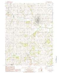
1985 Map of Stanberry
USGS Topo · Published 1985About this map
Stanberry serves as the primary hub of activity in this 1980s corner of Gentry County, defined by its traditional grid and essential infrastructure like the Radio Tower (KSTB) and a Sew Disp Plant. The surrounding landscape is a complex drainage network where Wildcat Creek and Moccasin Creek carve through the townships of Cooper and Washington. To the south, the small settlement of Island City sits near the confluence of Turkey Creek and Island Creek, reflecting a rural Missouri community organized around its waterways and local cemeteries. The map traces the utilitarian features of the era, from a Wooden Pole Trans Line and Pipeline to a Roadside Pk on the eastern edge. This survey documents the intersection of Gentry, Nodaway, and Andrew counties just as modern utility corridors were firmly established across the agricultural plains.
Find a feature on this map
22 named features on this map. Tap any name to fly to it.
Don’t see what you’re looking for? This feature index may not catch every label — zoom into the map to look around manually.
Map Details
Editions of this 1985 Stanberry Map
This is the sole edition of this map. No revisions or reprints were ever made.
Other maps of this area

1925 · Stanberry
USGS Topo · 1:62,500

1925 · Darlington
USGS Topo · 1:62,500

1939 · Stanberry
USGS Topo · 1:62,500

1940 · Parnell
USGS Topo · 1:62,500

1942 · Grant City
USGS Topo · 1:62,500

1943 · Parnell
USGS Topo · 1:62,500

1943 · Grant City
USGS Topo · 1:62,500

1943 · Stanberry
USGS Topo · 1:62,500

1950 · Darlington
USGS Topo · 1:62,500

1955 · Nebraska City
USGS Topo · 1:250,000