1959 Map of Standard Wash
USGS Topo · Published 1960About this map
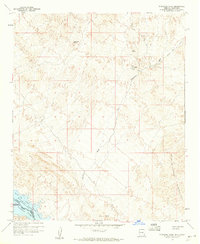
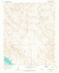
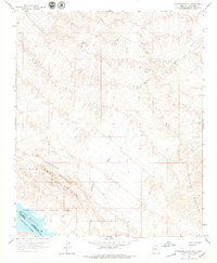
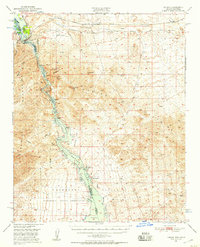
Manitowoc Mine and El Campo Mine are prominent markers of resource extraction in this arid landscape near the Colorado River. The terrain is defined by the seasonal drainage of Standard Wash as it cuts toward the shoreline of Havasu Lake. The map reveals a complex intersection of land management and natural boundaries, including the Havasu National Wildlife Refuge and the Chemehuevi Indian Res Bdy. Local water sources like Screwbean Spring and Gold Spring provide critical landmarks amidst the Aubrey Hills and the rising slopes of the Bill Williams Mountains. This 1950s survey documents a network of primitive transportation, including a Jeep Trail and the Dutch Flat Road, highlighting the era's reliance on rugged access routes for mining and exploration in the borderlands between Arizona and California.
Find a feature on this map
19 named features on this map. Tap any name to fly to it.
Don’t see what you’re looking for? This feature index may not catch every label — zoom into the map to look around manually.
Map Details
Editions of this 1959 Standard Wash Map
3 editions found
Other maps of this area

1903 · Needles
USGS Topo · 1:125,000

1904 · Needles Special
USGS Topo · 1:125,000

1911 · Parker
USGS Topo · 1:125,000

1927 · Buck Mountains
USGS Topo · 1:62,500

1929 · Buck Mountains
USGS Topo · 1:62,500

1943 · Giers Basin
USGS Topo · 1:62,500

1943 · Topock
USGS Topo · 1:62,500

1943 · Whipple Mts.
USGS Topo · 1:62,500
1950 · Parker Dam Area
USGS Topo · 1:62,500
1950 · Topock
USGS Topo · 1:62,500