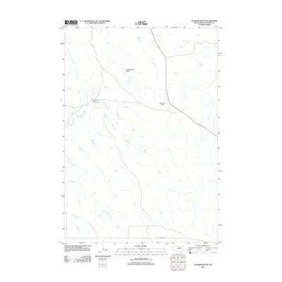
2012 Map of Standing Butte
USGS Topo · Published 2012About this map
Standing Butte Triple-U Buffalo Ranch anchors this portion of Stanley County, representing a modern chapter of land use in the central South Dakota plains. The terrain is defined by the high point of Standing Butte and the drainage patterns of the E Fork Minneconjou Cr and Chantier Cr, which cut through the open rangeland. The presence of Buck Williams Draw suggests the local naming of geographical features by ranching families and early settlers. This 2012 survey illustrates the sparse infrastructure of the region, where Sansarc Rd serves as a primary artery through a landscape dedicated to large-scale ranching and bison conservation. The map reveals the intricate network of seasonal streams and draws that dictate the movement of livestock and the placement of rural homesteads in this part of the Great Plains.
Find a feature on this map
6 named features on this map. Tap any name to fly to it.
Don’t see what you’re looking for? This feature index may not catch every label — zoom into the map to look around manually.
Map Details
Editions of this 2012 Standing Butte Map
This is the sole edition of this map. No revisions or reprints were ever made.
Other maps of this area

1937 · Oahe
USGS Topo · 1:62,500

1954 · Pierre
USGS Topo · 1:250,000

1956 · Crockett Mountains
USGS Topo · 1:24,000

1958 · Pierre
USGS Topo · 1:250,000

1973 · Iron Post Buttes SW
USGS Topo · 1:24,000

1973 · Iron Post Buttes
USGS Topo · 1:24,000

1980 · Princes Ranch
USGS Topo · 1:25,000
1982 · Lacy
USGS Topo · 1:24,000

1982 · Mission Ridge
USGS Topo · 1:24,000

1983 · Standing Butte
USGS Topo · 1:24,000