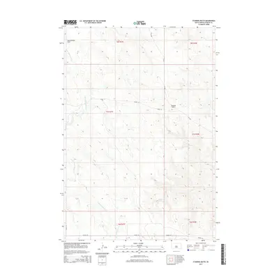
2015 Map of Standing Butte
USGS Topo · Published 2015About this map
Standing Butte dominates the central horizon of this Stanley County landscape, providing a primary landmark for the high plains topography west of the Missouri River. The terrain is defined by a dense network of drainages and coulees, most notably the E Fork Minneconjou Cr which meanders across the western half of the quadrangle. In the south, Chantier Cr cuts through the prairie, while Buck Williams Draw marks the northwestern reaches. This 2015 survey illustrates a sparsely populated ranching region where infrastructure is limited to long-distance routes like Sansarc Rd and SD-1806. The map captures the vast township and range sections of the Dakotas, showing how the land was partitioned for agricultural use near local thoroughfares such as Tatanka Pl.
Find a feature on this map
14 named features on this map. Tap any name to fly to it.
Don’t see what you’re looking for? This feature index may not catch every label — zoom into the map to look around manually.
Map Details
Editions of this 2015 Standing Butte Map
This is the sole edition of this map. No revisions or reprints were ever made.
Other maps of this area

1937 · Oahe
USGS Topo · 1:62,500

1954 · Pierre
USGS Topo · 1:250,000

1956 · Crockett Mountains
USGS Topo · 1:24,000

1958 · Pierre
USGS Topo · 1:250,000

1973 · Iron Post Buttes SW
USGS Topo · 1:24,000

1973 · Iron Post Buttes
USGS Topo · 1:24,000

1980 · Princes Ranch
USGS Topo · 1:25,000
1982 · Lacy
USGS Topo · 1:24,000

1982 · Mission Ridge
USGS Topo · 1:24,000

1983 · Standing Butte
USGS Topo · 1:24,000