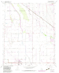
1965 Map of Stanfield
USGS Topo · Published 1983About this map
Stanfield serves as the primary hub of this Pinal County landscape, situated at the junction of the Southern Pacific railroad and a grid of local transport routes like White Parker Road and Barnes Road. The desert environment is defined by the ephemeral drainage of the Santa Cruz Wash and the Santa Rosa Greene Wash, illustrating the complex water management required for the surrounding agricultural tracts. Aerial photography from the 1960s and 1970s reveals a developing infrastructure, including the Stanfield Sch, a Radio Facility, and aviation sites such as Potters Airfield and a secondary Landing Strip. Large portions of the territory are managed as the Maricopa Indian Reservation and the Gila River Indian Reservation, reflecting the region's enduring tribal heritage and land use patterns during the mid-20th century.
Find a feature on this map
26 named features on this map. Tap any name to fly to it.
Don’t see what you’re looking for? This feature index may not catch every label — zoom into the map to look around manually.
Map Details
Editions of this 1965 Stanfield Map
2 editions found
Other maps of this area

1913 · Maricopa
USGS Topo · 1:62,500

1914 · Gila Butte
USGS Topo · 1:62,500

1915 · Maricopa
USGS Topo · 1:62,500

1917 · Gila Butte
USGS Topo · 1:62,500

1922 · Casa Grande
USGS Topo · 1:62,500

1924 · Casa Grande
USGS Topo · 1:62,500

1946 · Antelope Peak
USGS Topo · 1:62,500

1948 · Antelope Peak
USGS Topo · 1:62,500

1952 · Gila Butte SE
USGS Topo · 1:24,000

1952 · Maricopa
USGS Topo · 1:24,000