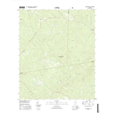
2017 Map of Stanfordville
USGS Topo · Published 2017About this map
Oconee National Forest encompasses a significant portion of this landscape at the junction of Jasper, Putnam, and Jones Counties. The small settlements of Stanfordville and Goolsby anchor the north, connected by a network of rural routes including Joe Phillips Rd and Dumas Rd. The terrain is defined by its complex drainage, where numerous creeks like Cedar Cr and Glady Cr flow toward significant local impoundments such as Dumas Lake and Hillsboro Lake. This 2017 data reflects a region where timberlands and private estates intersect, evidenced by family-named landmarks like Fullerton Cem and several private water bodies like Walker- Laney Lake. The road system, including Union Hill Church Rd, suggests the historical importance of local congregations in this quiet corner of the Georgia Piedmont.
Find a feature on this map
40 named features on this map. Tap any name to fly to it.
Don’t see what you’re looking for? This feature index may not catch every label — zoom into the map to look around manually.
Map Details
Editions of this 2017 Stanfordville Map
This is the sole edition of this map. No revisions or reprints were ever made.
Other maps of this area

1953 · Athens
USGS Topo · 1:250,000

1958 · Athens
USGS Topo · 1:250,000

1959 · Athens
USGS Topo · 1:250,000

1963 · Athens
USGS Topo · 1:250,000

1964 · Gray
USGS Topo · 1:24,000
1964 · Dames Ferry
USGS Topo · 1:24,000

1964 · Stanfordville
USGS Topo · 1:24,000

1964 · Hillsboro
USGS Topo · 1:24,000

1972 · Monticello
USGS Topo · 1:24,000

1972 · Eatonton
USGS Topo · 1:24,000