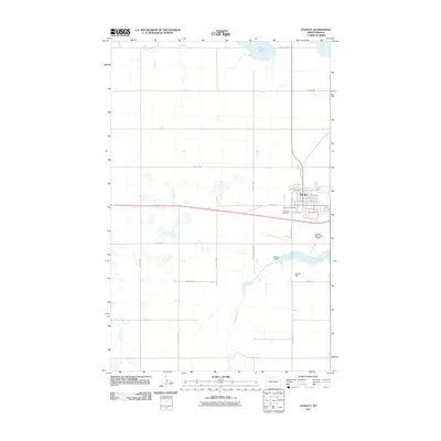
2011 Map of Stanley
USGS Topo · Published 2011About this map
Stanley serves as the focal point of this Mountrail County landscape, where the grid of the town meets the open plains of North Dakota. The settlement is organized around a detailed street network featuring Railroad Ave and numerous residential avenues, reflecting its history as a prairie rail hub. To the north, the waters of White Lake anchor the prairie terrain, while the Little Knife River winds through the southern portion of the quadrangle. Infrastructure and community landmarks are clearly marked, including the Stanley Municipal Airport and Fairview Cemetery. The presence of the Stanley Dam along the river highlights local water management and its importance to the surrounding agricultural region. This survey provides a clear look at the intersection of rural transport routes like County Rd 22 and the established town center during a period of modern development.
Find a feature on this map
26 named features on this map. Tap any name to fly to it.
Don’t see what you’re looking for? This feature index may not catch every label — zoom into the map to look around manually.
Map Details
Editions of this 2011 Stanley Map
This is the sole edition of this map. No revisions or reprints were ever made.
Other maps of this area

1953 · Williston
USGS Topo · 1:250,000

1957 · Williston
USGS Topo · 1:250,000

1969 · Stanley
USGS Topo · 1:24,000

1969 · Stanley SE
USGS Topo · 1:24,000

1981 · Robinson Lake
USGS Topo · 1:24,000

1981 · Ross
USGS Topo · 1:24,000

1981 · Stanley SE
USGS Topo · 1:24,000

1981 · Lostwood
USGS Topo · 1:24,000
1981 · Cottonwood Lake
USGS Topo · 1:24,000
1981 · Sikes Dam
USGS Topo · 1:24,000