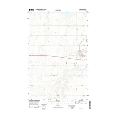
2014 Map of Stanley
USGS Topo · Published 2014About this map
Stanley serves as the central hub of this North Dakota landscape, situated at a junction where local roads meet the regional transit corridor of Old Highway 2. The town's layout is clearly defined by its relationship to the rail lines, with streets like Railroad Ave and Reservoir Rd bordering the northern residential and commercial blocks. To the south, the Stanley Municipal Airport occupies a flat plateau above the winding path of the Little Knife River, which carves a distinct valley through the prairie as it flows toward the southeast corner of the quadrangle.
Find a feature on this map
21 named features on this map. Tap any name to fly to it.
Don’t see what you’re looking for? This feature index may not catch every label — zoom into the map to look around manually.
Map Details
Editions of this 2014 Stanley Map
This is the sole edition of this map. No revisions or reprints were ever made.
Other maps of this area

1953 · Williston
USGS Topo · 1:250,000

1957 · Williston
USGS Topo · 1:250,000

1969 · Stanley
USGS Topo · 1:24,000

1969 · Stanley SE
USGS Topo · 1:24,000

1981 · Robinson Lake
USGS Topo · 1:24,000

1981 · Ross
USGS Topo · 1:24,000

1981 · Stanley SE
USGS Topo · 1:24,000

1981 · Lostwood
USGS Topo · 1:24,000
1981 · Cottonwood Lake
USGS Topo · 1:24,000
1981 · Sikes Dam
USGS Topo · 1:24,000