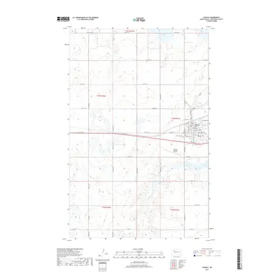
2017 Map of Stanley
USGS Topo · Published 2017About this map
The city of Stanley serves as the focal point of this Mountrail County landscape, situated at the crossroads of several significant transit corridors. The township is characterized by a grid of rural roads and the undulating course of the Little Knife River, which flows through the southern portion of the quadrangle. North of the city center, White Lake marks a significant topographical feature, while the Stanley Municipal Airport and Fairview Cem provide landmarks on the city's southern outskirts. Modern transportation networks are represented by Old Hwy 2, Frontage Rd, and Reservoir Rd, which facilitate movement through this agricultural and prairie region. The map details the transition from the structured street grid of the town site to the expansive rural sections that define the North Dakota plains, offering a clear view of the regional infrastructure as it existed in the late twenty-tens.
Find a feature on this map
41 named features on this map. Tap any name to fly to it.
Don’t see what you’re looking for? This feature index may not catch every label — zoom into the map to look around manually.
Map Details
Editions of this 2017 Stanley Map
This is the sole edition of this map. No revisions or reprints were ever made.
Other maps of this area

1953 · Williston
USGS Topo · 1:250,000

1957 · Williston
USGS Topo · 1:250,000

1969 · Stanley
USGS Topo · 1:24,000

1969 · Stanley SE
USGS Topo · 1:24,000

1981 · Robinson Lake
USGS Topo · 1:24,000

1981 · Ross
USGS Topo · 1:24,000

1981 · Stanley SE
USGS Topo · 1:24,000

1981 · Lostwood
USGS Topo · 1:24,000
1981 · Cottonwood Lake
USGS Topo · 1:24,000
1981 · Sikes Dam
USGS Topo · 1:24,000