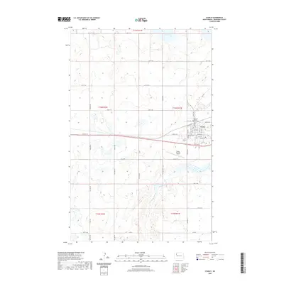
2020 Map of Stanley
USGS Topo · Published 2020About this map
Stanley serves as the focal point of this Mountrail County landscape, where the local government is centered at the Mountrail County Courthouse. The town's layout is defined by a grid of streets including Main St and 1st Ave NW, situated north of the Stanley Municipal Airport. Outside the immediate town center, the terrain is shaped by the winding Little Knife River to the south and the presence of White Lake in the northern portion of the quadrangle. Transportation patterns are evident in the corridors of Old Hwy 2 and the modern frontage roads that parallel the primary east-west thoroughfare. For those researching local heritage, the Fairview Cem is located just west of the main residential area. The surrounding landscape is dominated by section lines and township boundaries like t156n r91w, reflecting the persistent influence of the Public Land Survey System on the North Dakota plains.
Find a feature on this map
40 named features on this map. Tap any name to fly to it.
Don’t see what you’re looking for? This feature index may not catch every label — zoom into the map to look around manually.
Map Details
Editions of this 2020 Stanley Map
This is the sole edition of this map. No revisions or reprints were ever made.
Other maps of this area

1953 · Williston
USGS Topo · 1:250,000

1957 · Williston
USGS Topo · 1:250,000

1969 · Stanley
USGS Topo · 1:24,000

1969 · Stanley SE
USGS Topo · 1:24,000

1981 · Robinson Lake
USGS Topo · 1:24,000

1981 · Ross
USGS Topo · 1:24,000

1981 · Stanley SE
USGS Topo · 1:24,000

1981 · Lostwood
USGS Topo · 1:24,000
1981 · Cottonwood Lake
USGS Topo · 1:24,000
1981 · Sikes Dam
USGS Topo · 1:24,000