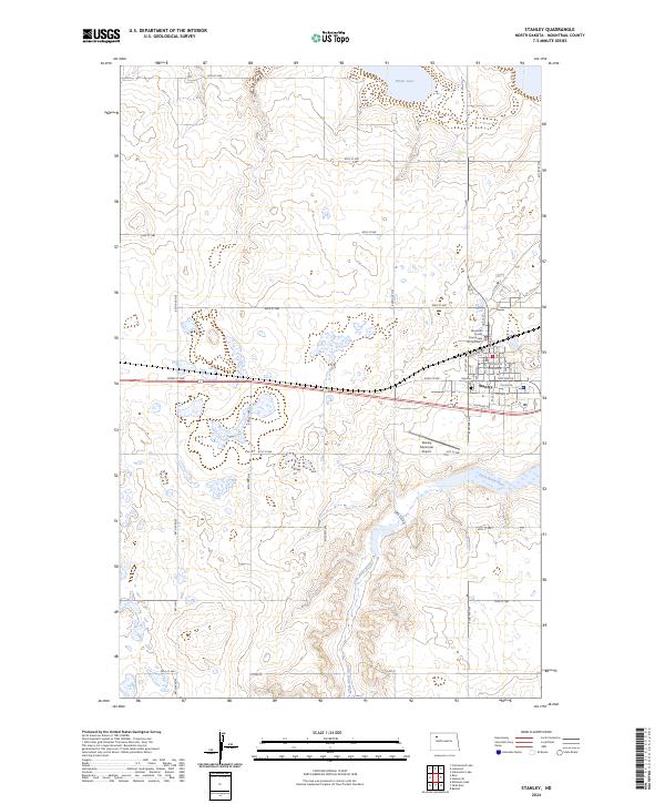
2024 Map of Stanley
USGS Topo · Published 2024About this map
Stanley serves as the focal point of this Mountrail County landscape, situated where the high plains of North Dakota meet the winding path of the Little Knife River. The town's layout is centered around the Mountrail County Courthouse and follows a grid that aligns with the railway corridor along Railroad Ave. Outside the town center, the terrain is characterized by numerous prairie potholes and wetlands, including White Lake and the Mountrail County Waterfowl Production Area, which dominate the northern and western sections of the quadrangle. Transportation remains a defining element of the area's development, visible in the convergence of modern routes and historical paths like Old Hwy 2. Notable local landmarks such as Fairview Cem and the Stanley Municipal Airport provide specific points of interest for those researching local family history or the infrastructure of this agricultural hub.
Find a feature on this map
43 named features on this map. Tap any name to fly to it.
Don’t see what you’re looking for? This feature index may not catch every label — zoom into the map to look around manually.
Map Details
Editions of this 2024 Stanley Map
This is the sole edition of this map. No revisions or reprints were ever made.
Other maps of this area

1953 · Williston
USGS Topo · 1:250,000

1957 · Williston
USGS Topo · 1:250,000

1969 · Stanley
USGS Topo · 1:24,000

1969 · Stanley SE
USGS Topo · 1:24,000

1981 · Robinson Lake
USGS Topo · 1:24,000

1981 · Ross
USGS Topo · 1:24,000

1981 · Stanley SE
USGS Topo · 1:24,000

1981 · Lostwood
USGS Topo · 1:24,000
1981 · Cottonwood Lake
USGS Topo · 1:24,000
1981 · Sikes Dam
USGS Topo · 1:24,000