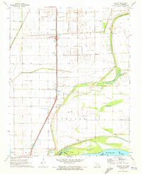
1971 Map of Stanley
USGS Topo · Published 1973About this map
Mississippi River bottomlands dominate this 1971 survey of the Missouri-Tennessee borderlands, where a complex network of bayous and drainage canals defines the agricultural landscape of Godair and Butler townships. The settlement at Stanley serves as a central point, anchored by the North Pemiscot School and nearby North Pemiscot Jr High Sch. The region's spiritual and community life is evidenced by numerous country churches, including Bethlehem Ch and Mt Carmel Ch. Transport relies on the St Louis - San Francisco railroad line, which runs parallel to the river's historic floodplains. Below the levees, the terrain shifts into the shifting sands of Sandy Hook Bar and the winding waters of Robinson Bayou, illustrating the precarious boundary between reclaimed farmland and the river's edge.
Find a feature on this map
31 named features on this map. Tap any name to fly to it.
Don’t see what you’re looking for? This feature index may not catch every label — zoom into the map to look around manually.
Map Details
Editions of this 1971 Stanley Map
2 editions found
Other maps of this area

1939 · Portageville
USGS Topo · 1:62,500

1939 · Caruthersville
USGS Topo · 1:62,500

1940 · Pascola
USGS Topo · 1:62,500

1940 · Hayti
USGS Topo · 1:62,500

1951 · Caruthersville
USGS Topo · 1:62,500

1955 · Pascola
USGS Topo · 1:62,500

1955 · Hayti
USGS Topo · 1:62,500

1955 · Portageville
USGS Topo · 1:62,500

1956 · Dyersburg
USGS Topo · 1:250,000

1957 · Caruthersville
USGS Topo · 1:62,500