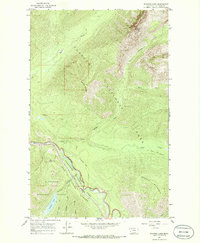
1964 Map of Stanton Lake
USGS Topo · Published 1986About this map
Glacier National Park and Flathead National Forest meet along the dramatic corridor of the Middle Fork Flathead River in this mid-1960s topographic record. The landscape is defined by the sharp transition from the river valley to high peaks like Threesuns Mountain and Double Mountain. Running parallel to the river, the Great Northern railroad line traverses John F Stevens Canyon, highlighting the critical transportation artery that carved through this mountain pass.
Find a feature on this map
22 named features on this map. Tap any name to fly to it.
Don’t see what you’re looking for? This feature index may not catch every label — zoom into the map to look around manually.
Map Details
Editions of this 1964 Stanton Lake Map
2 editions found
Other maps of this area

1904 · Chief Mountain
USGS Topo · 1:125,000

1914 · Nyack
USGS Topo · 1:125,000

1938 · Chief Mountain
USGS Topo · 1:125,000

1960 · Cut Bank
USGS Topo · 1:250,000

1963 · Cut Bank
USGS Topo · 1:250,000

1964 · Cut Bank
USGS Topo · 1:250,000

1964 · Essex
USGS Topo · 1:24,000

1964 · Nyack
USGS Topo · 1:24,000

1964 · Pinnacle
USGS Topo · 1:24,000

1964 · Stanton Lake
USGS Topo · 1:24,000