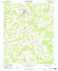
1978 Map of Stantonsburg
USGS Topo · Published 1978About this map
Stantonsburg serves as the focal point of this Eastern North Carolina landscape, where the Norfolk Southern railroad tracks intersect with the slow-moving waters of Contentnea Creek. In the late 1970s, this region remained heavily agricultural, defined by expansive swamp networks including Toisnot Swamp, Appletree Swamp, and Nahunta Swamp. These wetlands dictate the distribution of small rural settlements like Eureka, Faro, and Yelverton. The map provides significant genealogical value through its density of country churches and associated burial grounds, such as St Lukes Ch, Union Grove Ch, and Salisbury Ch. The presence of numerous sandpits and a sewage disposal site near the main township indicates the local infrastructure and industry of the era, while named locations like Applewhite and Honeycutt preserve the identity of historic family landholdings across Wilson, Wayne, and Greene counties.
Find a feature on this map
38 named features on this map. Tap any name to fly to it.
Don’t see what you’re looking for? This feature index may not catch every label — zoom into the map to look around manually.
Map Details
Editions of this 1978 Stantonsburg Map
This is the sole edition of this map. No revisions or reprints were ever made.
Other maps of this area

1904 · Falkland
USGS Topo · 1:62,500

1904 · Wilson
USGS Topo · 1:62,500

1914 · Kinston
USGS Topo · 1:48,000

1916 · Kinston
USGS Topo · 1:62,500

1953 · Rocky Mount
USGS Topo · 1:250,000

1954 · Rocky Mount
USGS Topo · 1:250,000

1957 · Goldsboro
USGS Topo · 1:62,500
1978 · Fremont
USGS Topo · 1:24,000
1978 · Saratoga
USGS Topo · 1:24,000
1978 · Wilson
USGS Topo · 1:24,000