
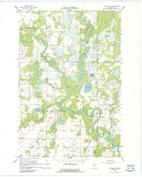
1966 Map of Staples NE
USGS Topo · Published 1967About this map
The Crow Wing River and its major tributaries, the Leaf River and Partridge River, define the landscape of this central Minnesota region during the mid-1960s. This survey illustrates the intricate wetlands and oxbow lakes formed by these meandering waterways, including Simon Lake, Radabaugh Lake, and Lovejoy Lake. The human footprint is concentrated along section roads, featuring local landmarks such as Covenant Ch, Montrose Cem, and the Staples Municipal Airport in the south.
Find a feature on this map
25 named features on this map. Tap any name to fly to it.
Don’t see what you’re looking for? This feature index may not catch every label — zoom into the map to look around manually.
Map Details
Editions of this 1966 Staples NE Map
2 editions found
Other maps of this area

1919 · Leader
USGS Topo · 1:62,500

1953 · Brainerd
USGS Topo · 1:250,000

1957 · Brainerd
USGS Topo · 1:250,000

1958 · Brainerd
USGS Topo · 1:250,000

1963 · Motley
USGS Topo · 1:24,000

1965 · Brainerd
USGS Topo · 1:250,000
1966 · Motley NW
USGS Topo · 1:24,000

1966 · Staples
USGS Topo · 1:24,000

1966 · Aldrich North
USGS Topo · 1:24,000

1966 · Aldrich South
USGS Topo · 1:24,000